Addressing Long Commute Times along the Slauson Corridor
In 2018, the city of Los Angeles received a grant to develop a neighborhood-level climate resiliency plan for South Los Angeles. Working with community-based organizations
Variable Definitions:
Bikes or Walks: The percentage of the working population that bikes or walks to get to and from work for the majority of a typical work week
Carpools: The percentage of the working population that rides with two or more people in a vehicle to get to and from work for the majority of a typical work week
Drives Alone: The percentage of the working population that drives alone to get to and from work for the majority of a typical work week
Public Transit: The percentage of the working population that uses public transportation to get to and from work for the majority of a typical work week
Works from Home: The percentage of the working population that works from home for the majority of a typical work week
Source:
American Community Survey, 5-year estimates, Table B08301
Years Available:
2010 – 2024
*Note: Each year of available data shown above is a 5-year estimate, or an average of data collected over a five year period. 5-year estimates are used to increase the reliability of the data at small geographies like neighborhoods and census tracts. The years shown on the NDSC map represent the final year of the five year average (e.g. “2010” represents 2006-2010 data, “2011” represents 2007-2011 data, and so on). For the most impactful comparison of data over time, the ACS recommends comparing non-overlapping years (e.g. 2010-14 with 2015-19).
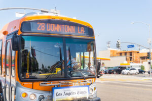
Public Transit Use
Although Los Angeles typically ranks low in public transit use when compared to other major metropolitan areas in the U.S., bus and rail systems are a key solution to consider when addressing traffic and pollution concerns in the county. For many individuals without vehicles, public transportation also serves as the only available form of transportation to and from work. In the November 2016 election, Los Angeles county voters passed Measure M, which uses a 1/2 cent sales tax increase to fund a number of transportation projects, including a massive expansion of rail transit availability across the county. Transit Ridership can be used to measure how neighborhoods with more access to public transit are using that resource. As public transit becomes more accessible across the county over time, this variable will be an important measure of effectiveness in transit planning.
Bikes or Walks
As traffic continues to worsen, some travelers have resorted to utilizing active transportation methods as a more reliable way to travel to work. However, pedestrian and bicycle accidents are common in a region that was built for automobiles not pedestrians. Programs such as LADOT Livable Streets have been implemented to provide safe streets that encourage mixed modal uses for transportation and recreation. Understanding the number of people who choose to bike to walk to work provides information as to where to focus efforts on improving bicycle lane safety as well as shared bicycle access and storage. Additionally, where projects have already been undertaken, this variable can be useful in measuring not only its effectiveness in encouraging active transportation but also improvements in safety conditions for riders.
Carpools
Carpooling describes the practice of travelling with two or more people in a vehicle. In California, vehicles practicing carpooling often have access to designated lanes called High-Occupancy Vehicle (HOV) lanes (also known as carpool or diamond lanes) to promote and encourage ridesharing; thereby alleviating congestion and maximizing the people-carrying capacity of California highways. Over the past 30 years, Los Angeles County has developed over 513 lane miles of HOV facilities including freeway HOV lanes, HOV access ramps, and park-and-ride lots along HOV corridors. Spanning across five counties, the HOV system in the LA metro region is one of the largest in the country.
Understanding the number of travelers who choose to regularly carpool to get to work can help guide transportation agencies when implementing new highway projects to determine which region could benefit most from HOV projects. Additionally, this variable provides a measure of effectiveness of highway projects.
Drives Alone
For decades, the Los Angeles region has experienced crippling congestion and poor air quality attributed to excessive automobile use. Efforts to influence travel behavior, such as public transit expansion and HOV lanes, are used to support reducing energy use, emissions and congestion. Although the region has implemented various transportation projects, public transit and carpool use has declined in recent years. Understanding the number of people who drive alone helps policymakers measure the effectiveness of various transportation projects while also provide a guide to where additional measures may be needed in order to encourage a reduction in vehicle trips traveled.
Works from Home
The percentage of Los Angeles remote workers more than doubled after the onset of the COVID-19 pandemic. In 2019, prior to the pandemic, 6% of Angelenos worked from home. After the pandemic, this rose to roughly 13% in 2022.
Research indicates that access to remote-work opportunities are heavily skewed to highly paid individuals and/or those with more education and more experience, and are often presented far more often for those working full-time rather than part-time. Gaps in remote work offerings along each of these dimensions has only widened since 2019 (Lambert, et al., 2023). Those with the opportunity to work from home may enjoy increased flexibility in their work and home lives, and spend less time and money on commuting. At the same time, prior education and experience, internet and computer access, and access to stability, safety and space at home may limit access to the benefits of remote work for certain households.
See also: Commute Time, Pedestrian and Cyclist Access
Written by Dan Hoornbeek
Citation:
Fischer-Baum, Reuben. “How your city’s public transit stacks up.” FiveThirtyEight, 31 July 2014. Link.
“HOV (Carpool) Lanes”. LA Metro. Link.
“Livable Streets Project: Active Transportation”. LA Department of Transportation. Link.
“Measure M: Metro’s Plan to Transform Transportation in LA.” Metro, 2018. Link.
Nelson, Laura J. “Next phase of the Wilshire subway receives $1.6 billion in federal funds.” Los Angeles Times, 4 January 2017. Link.
U.S. Department of Energy. “Effects of Travel Reduction and Efficient Driving on Transportation: Energy Use and Greenhouse Gas Emissions”. 2013. Link.
Lambert, et al. (2023). “Research: The growing inequality of who gets to work from home.” Harvard Business Review. Link.
In 2018, the city of Los Angeles received a grant to develop a neighborhood-level climate resiliency plan for South Los Angeles. Working with community-based organizations
Access to cost effective, time efficient and environmentally conscious transportation is a pressing issue affecting people around the world. In 2017, INRIX Global Traffic Scorecard
Across Los Angeles County’s vast and sprawling 4,751 square miles, more than 4.5 million commuters walk, bike, drive, rideshare or take public transit to get
