These neighborhood profiles highlight the intersections of COVID-19 and other social and economic indicators in specific neighborhoods throughout Los Angeles County.
COVID-19 Neighborhood Profiles
Although COVID-19 is an issue affecting people around the United States and the globe, its impact differs widely across local communities and neighborhoods. Air quality, population density, and access to resources like hospitals and testing centers are just a few of the factors that impact the severity of cases and deaths in a community. Additionally, the pandemic has had wide reaching impacts on important factors outside of health like employment, housing, food access, and education.
These neighborhood profiles highlight the intersections of COVID-19 and other social and economic indicators in specific neighborhoods throughout Los Angeles County. They are a feature of the NDSC COVID-19 Dashboard.
East Los Angeles & the Digital Divide
As schools closed under the “Safer at Home” order in the Spring of 2020, students were forced to resume their schooling remotely online. However, computer and/or internet access differs widely across communities in LA County.
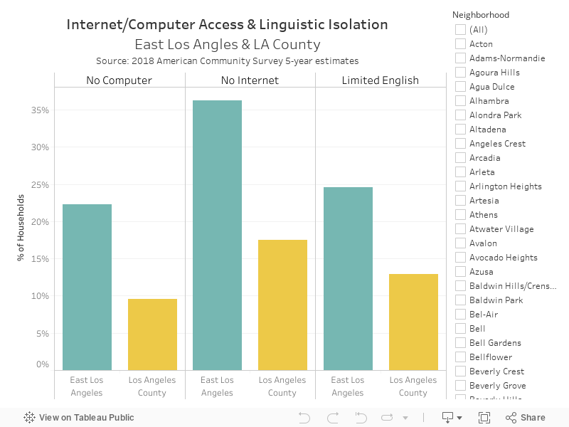
East Los Angeles is an unincorporated neighborhood in the Eastside region of Los Angeles County. As of June 31, 2020 East LA had the third highest cases of COVID-19 (2507) and 7th highest deaths (59) in the LA County. Although over 26% of East LA’s total population (117,348) is under the age of 18, over 22% of households in the neighborhood have no access to a computer – more than double the county average of 10%. Similarly, 36% of households in East LA do not have access to internet in their homes compared to the county average of 18%. The challenges presented by lack of internet and computer access for East LA families during COVID school closures are likely further complicated by the fact that nearly 25% of the households in the neighborhood have limited English proficiency.
The chart to the right shows computer/internet access and English proficiency for East LA and LA County. Select your neighborhood from the menu to add it to the chart.
The impact of school closures on student proficiency and educational attainment is yet to be determined. However, amid uncertainty as to when schools will reopen, school districts must address the digital divide in certain communities in order to ensure continued, quality education for vulnerable students who may face challenges to learning at home.
Food Services Jobs in Pico-Union
According to a recent Pew Research report, workers in industries including restaurants and bars, hotels, and retail trade services are at a higher risk of virus-related layoffs due to countywide closures of many businesses. This is exasperated by the fact that Los Angeles is home to 26% of the state’s accommodation and food service jobs and 8.3% of all hospitality jobs. Young workers make up 24% of employment in these industries nationwide and will therefore be disproportionately affected by COVID-19 layoffs. A recent spike in COVID-19 cases and deaths in LA County has halted reopening plans and have put an additional economic strain on already struggling businesses.
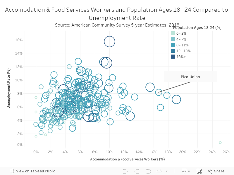
Pico-Union is a neighborhood in the City of Los Angeles. As of July 27th, Pico-Union ranked in the top 10 neighborhoods for total deaths due to COVID-19, with a death rate of 185 per 100,000 persons. Additionally, while only 6% of LA County’s workforce is employed in the accommodation and food services industry, 17% of Pico-Union’s employed population works in this industry. Further, over 10% of Pico Union’s population are between the ages of 18 and 24. Prior to the onset of the pandemic and subsequent economic crisis, Pico-Union had a higher rate of unemployment (8.5%) compared to the rest of the county (6.8%). Given the uncertainty surrounding the reopening of the county, it is likely that residents of Pico-Union will suffer a disproportionate economic impact due to the prevalence of accommodation and food service jobs in the neighborhood.
Hover over the circles on the chart below to see the percent of workers employed in the accommodation & food services industry, the percent of the population that is ages 18 to 24, and the unemployment rate in a specific neighborhood.
Westlake & Housing Vulnerability
Many of Los Angeles’ majority renter population were feeling the pressure of the region’s housing crisis, which has been fueled by rising rents and stagnant wages, well before the pandemic. However, the economic and health fallout from the pandemic and subsequent shutdown are expected to put additional pressure on many of the county’s renters.
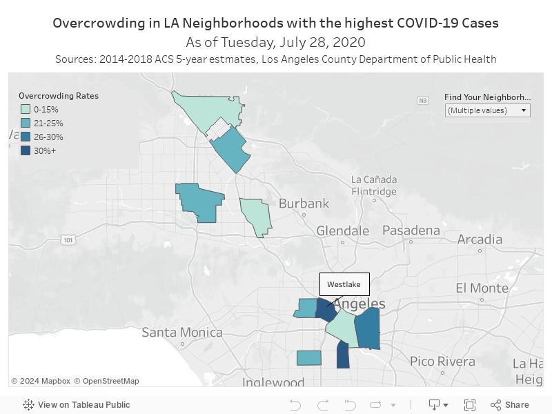
As of July 23, 2020, Westlake, a neighborhood just west of Downtown LA, had the highest COVID-19 cases (2,865) and the highest COVID-19 related deaths (143) of any neighborhood in the City of Los Angeles. Westlake also has some of the most cramped living conditions in the country. 38% of households are considered to be living in overcrowded housing, with more than one person per one room, compared to an average of 11% across the county. Overcrowded housing has been found to correlate with higher infections rates per capita and can put residents at greater risk of contracting the virus. Additionally, overcrowding is a result of the city’s housing crisis that has more and more families doubling up, living with relatives etc. Over 95% of households in Westlake rent (rather than own) their housing, and 59% of renters in the neighborhood are considered to be rent-burdened, meaning that they pay more than a third of their income on rent.
The map to the left shows overcrowding rates in Westlake and 9 other neighborhoods experiencing some of the highest COVID-19 case rates. Select your neighborhood from the menu to add it to the map.
59% of the population in Westlake are immigrants, 73% of which are non-citizens, meaning that many of these residents have been left out of unemployment benefits and COVID-related relief programs. The economic impacts of COVID-19 may place many residents of the neighborhood in imminent danger of eviction once certain protections such as the County’s moratorium on evictions, which has been extended through September, are lifted.

Mackenzie Goldberg
Mackenzie Goldberg is a Master of Urban Planning student at USC Price. She holds a bachelor’s degree in Religious Studies from Reed College in Portland, OR. Prior to coming to USC, Mackenzie worked as a writer and editor for an architectural publication based in Los Angeles, CA, where she came to understand the many ways in which policy undergirds our built environment. Her research interests lie at the cross-sector of planning policy, urban design, and community organizing. Through her work, she hopes to better engage communities in the systems that govern our cities.

Molly Creighton
Molly Creighton is a Master’s Student in the Public Policy Program at the University of Southern California’s Sol Price School of Public Policy. Currently, she is a data researcher at the Price Center for Social Innovation where she collects, analyzes and disseminates LA neighborhood-level data through data stories to community partners through the Neighborhood Data for Social Change (NDSC). She has also worked on jail reform initiatives in Alameda County, implementing a women’s health program within the county Jail. Her policy interests include sustainability, social justice and the intersection of mental health and incarceration.
Sources
COVID-19 Cases in New York City, a Neighborhood-Level Analysis. NYU Furman Center. Link
Photo Attributions
Cover Photo: Photo courtesy of Istock/georgeclerk
