Community Health in the I-710 Corridor
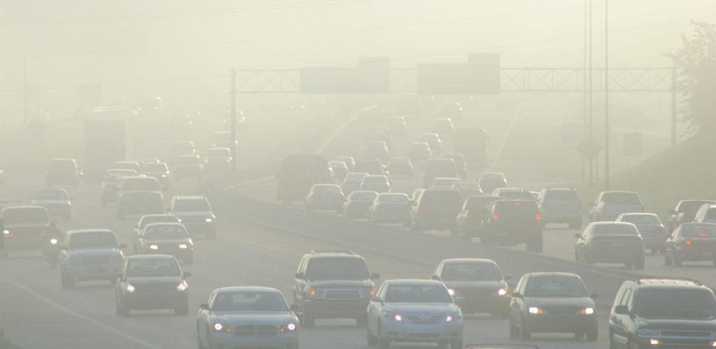
Public health experts agree that the environment we live in plays an important role in the quality of our daily lives and our long-term health. As such, pollution in the air, water, and soil threatens the overall well-being of the communities we live in. In 2019, the American Lung Association’s “State of the Air” report showed that more than 141 million people in the United States live in counties with pollution so bad that the air is dangerous to breathe. In terms of ozone quality, the same report ranks Los Angeles as the worst in the country.
With the health of our communities at stake, policymakers and activists need help identifying neighborhoods that are the most vulnerable to extreme pollution and public health hazards. This story debuts new data from the USC Program for Environmental and Regional Equity (PERE) that paints a more complete picture of how environmental and social vulnerability varies across neighborhoods in Los Angeles County. This story explores environmental concerns unique to a region highlighted by this new data, the I-710 Corridor, and community efforts to monitor and address them.
Environmental Justice
Although poor air quality in Los Angeles affects everyone, many neighborhoods face significantly greater risks to their health due to disproportionate exposure to environmental pollution and health hazards. For instance, more than 1.2 million people live in high pollution zones located just 500 feet from freeways in Southern California – a statistic that has increased by almost 4% from 2000 to 2010.
These neighborhoods tend to have a higher proportion of residents of color and higher rates of poverty and unemployment. These economic burdens make it even more difficult for residents to manage the elevated health risks associated with their environment. These disparities are defined by researchers, advocates, and policymakers as environmental justice concerns. Promoting environmental justice means highlighting communities that need targeted assistance to guarantee fair enforcement of environmental regulations.
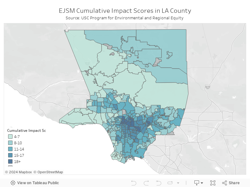
To assist this effort, PERE, in collaboration with community and research partners, developed the Environmental Justice Screening Method (EJSM). This data tool provides neighborhood-level scores for the cumulative impact of a community’s proximity to health hazards, exposure to pollution, social vulnerability, and climate change vulnerability.
I-710 Corridor
One environmental justice hot spot in Los Angeles flagged by this data is the I-710 Corridor. This region is made-up of 20 neighborhoods that line Interstate 710, also known as Long Beach Freeway. The area stretches from the ports of Los Angeles and Long Beach all the way up to central Los Angeles.
On a range from 0-20, with 20 being the highest level of cumulative impact, the average EJSM score for neighborhoods in the I-710 Corridor is 15 compared to the LA County average of 11. A score of 15 is in the 80th percentile for LA County, meaning that the cumulative impact for this area is equal to or greater than that for 80% of all other neighborhoods.
Explore the map below to see how EJSM scores in your neighborhood compare to the I-710 Corridor.
Freeways & Race
A closer look at the I-710 Corridor reveals how historical, environmental, and socioeconomic factors interact to explain the region’s relatively high EJSM ranking. More than 40% of all goods imported to the U.S. enter the country through the port of LA and port of LB. Most of these goods are then transported by large trucks along the Long Beach Freeway to railway stations in Commerce and Vernon that distribute the freight all over the country.
The location of this major trucking route, however, is emblematic of a historical pattern of negligent U.S. transportation policy. The 1960s boom in freeway construction advanced the country’s economic productivity, but at the cost of disrupting and displacing communities of color. Planners often built roads right in the middle of thriving Black neighborhoods, inciting community protests best summarized by the slogan, “No more white roads through black bedrooms.”
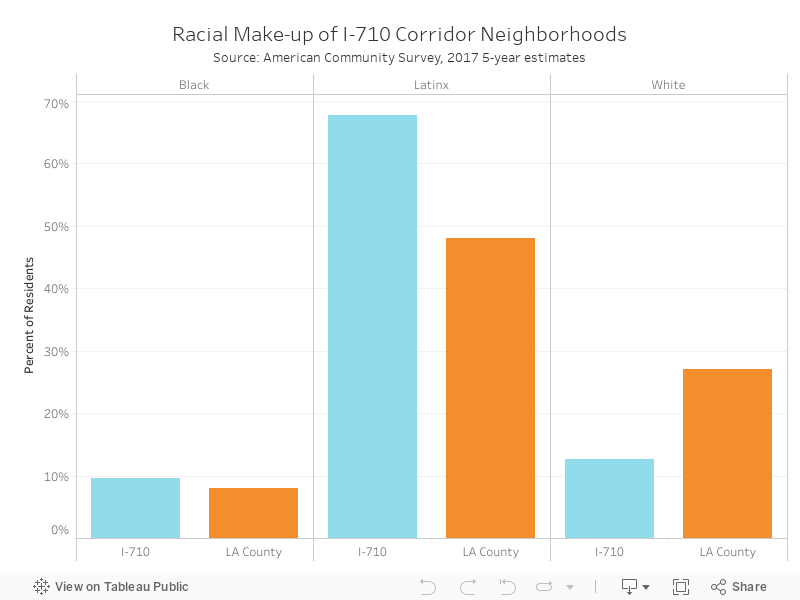
Today, neighborhoods in the I-710 Corridor are still disproportionately Black and Latinx. 77% of residents identify as either Black or Latinx compared to just 56% of LA County households. Meanwhile, white residents only account for 13% of residents, compared to 27% in LA County.
Therefore, communities of color bear the brunt of diesel emissions from a freeway that generates economic profits residents may never share. Annual averages provided by Caltrans in 2017 show that more than 20,000 trucks pass through sections of this freeway in a single day, which is more than twice the Los Angeles freeway average. What’s more, LA Metro predicts this traffic will more than double by 2035. Consequently, this region alone accounts for 20% of all particulate emissions in Southern California, which explains why some locals have taken to calling it a “diesel death zone.”
Dangers of Diesel
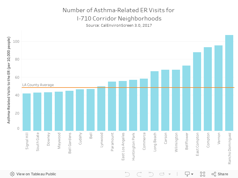
According to 2017 data from the CalEnviroScreen 3.0, neighborhoods in the I-710 Corridor average 36% more particulate matter concentrations than the LA County average. Even at moderate levels, particulate matter harms the short- and long-term health of people sensitive to it—typically young children, senior citizens, and people with respiratory illnesses. Studies find that those living in high emission zones are much more likely to develop asthma, heart disease, and lung cancer, and women are more likely to give birth prematurely.
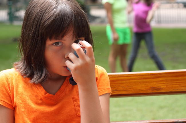
Furthermore, families of color living in the region are especially vulnerable to this toxic air pollution. According to the Asthma and Allergy Foundation of America in 2005, Black and Latinx children in the U.S. are statistically more likely to develop asthma and as a result experience poor health outcomes, including hospitalization or even death. Based on 2017 data from the CalEnvironScreen 3.0, residents in the 1-710 Corridor average 62 asthma-related visits to an emergency room per 10,000 people. On the other hand, neighborhoods in Los Angeles where more than 70% of residents are white average only 30 visits.
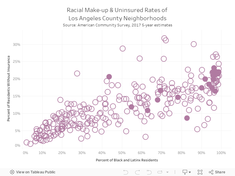
These elevated health risks are further complicated by economic burdens faced by these communities. I-710 Corridor residents are more likely to be unemployed (13%) and lack health insurance (16%) when compared to LA County averages (8% and 13% respectively). The graphic below illustrates a trend across LA County: neighborhoods with the highest concentration of Black and Latinx residents also have the highest uninsured rates. This makes it even more difficult to live in high pollution areas, because without health insurance or the money to pay out-of-pocket, children whose asthma is aggravated by dangerous air quality cannot access the medical help they need.
Explore the graphic below to see the relationship between the racial make-up of neighborhoods in LA County and their corresponding uninsured rates. The filled in circles are I-710 Corridor neighborhoods.
Fighting for Environmental Justice
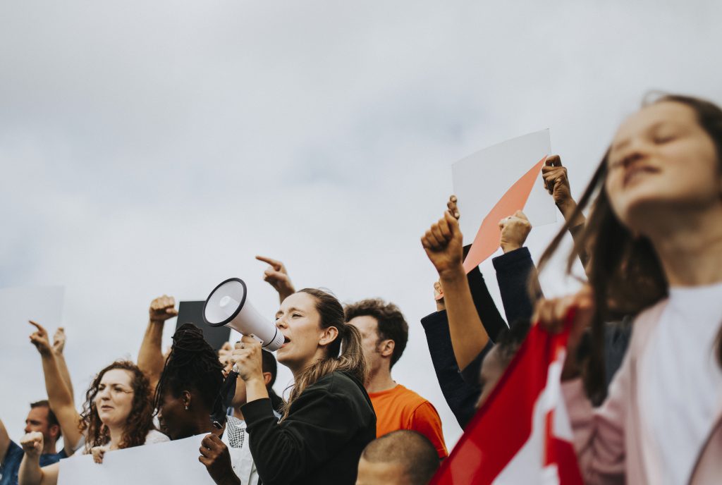
In 2007, researchers and community organizers joined forces to create the Los Angeles Collaborative for Environmental Health and Justice, a working group for investigating environmental justice concerns. As part of this objective, they organized community-based data collection projects, called “ground-truthing”, in three neighborhoods in the I-710 Corridor. The projects trained residents to monitor sources of pollution, based on the idea that residents experience first-hand the day-to-day operations of pollution sources.
Community groups are also organizing in response to LA County plans to widen the Long Beach Freeway. Caltrans projects that the $6 billion dollar I-710 expansion project would displace more than 100 homes and 158 businesses, all in the name of allowing even more cars and trucks on the road. With planners ignoring the concerns of those living in the shadow of the freeway, community groups like East Yard Communities for Environmental Justice (EYCEJ) have coordinated protests against the plan. Currently, Metro is working on a Final Environmental Impact Report (FEIR) for the plan.
As Los Angeles continues to develop housing near freeways and more families are forced to live in heavily polluted areas due to gentrification and displacement, grassroots efforts like these are crucial to sustaining the health and longevity of our communities. This work gets us closer to fulfilling the promise that every neighborhood, regardless of zip code, can cultivate a healthy environment for people to live, work, and thrive.

Colin Caprara
Colin Caprara is a Research Assistant at Price Center for Social Innovation and a Master of Public Policy student at University of Southern California. As a public policy researcher, Colin is interested in using data to improve equitable access to education, housing, and employment. Prior to USC, Colin worked at Reno & Cavanaugh PLLC where he conducted legal and political research on public housing. Before that, Colin served the U.S. Senate Select Committee on Ethics where he researched Congressional history, parliamentary rules, and case law.
Sources
American Lung Association (2019). The State of the Air. Accessed on June 13, 2019. Link.
Asthma and Allergy Foundation (2005). Ethnic Disparities in the Burden and Treatment of Asthma. Accessed on June 19, 2019. Link.
Barboze, T. & Schleuss, J. (2017). L.A. keeps building near freeways, even though living there makes people sick. Los Angeles Times. Accessed on June 18, 2019. Link.
Caltrans (2017). Traffic Census Program. Accessed on June 20, 2019. Link.
EPA (2019). Los Angeles Area Environmental Enforcement Collaborative. Accessed on June 12, 2019. Link.
Los Angeles County Department of Public Health (2018). Public Health and Safety Risks of Oil and Gas Facilities in Los Angeles County. Accessed on June 12, 2019. Link.
Sadd, J., Shamasunder, B., Osborn, B., Steva, E., Martinez, A., Garcia, Y., & Prichard, M. (2015). Drilling Down: The Community Consequenes of Expanded Oil Development in Los Angeles. Liberty Hill Foundation: Los Angeles, CA, USA. Accessed on June 17, 2019. Link.
Sadd, J., Morello-Frosch, R., Pastor, M., Matsuoka, M., Prichard, M., & Carter, V. (2014). The truth, the whole truth, and nothing but the ground-truth: Methods to advance environmental justice and researcher–community partnerships. Accessed on June 18, 2019. Link.
Srebotnjak, Tanja & Rotkin-Ellman, Miriam (2014). Drilling in California: Who’s at risk? National Resource Defense Council. Accessed on June 12, 2019. Link.
Wick, Julie (2018). L.A. Taps the Brakes on Freeway Expansion. City Lab. Accessed on June 26, 2019. Link.
Picture 4: Molly Adam via Flickr
Photo Attributions
Cover Photo: Photo courtesy of Istock/InkkStudios
Photo 1: Photo courtesy of Istock/plherrera
Photo 2: Photo courtesy of Istock/princessdlaf
Photo 3: Photo courtesy of Istock/Rawpixel
